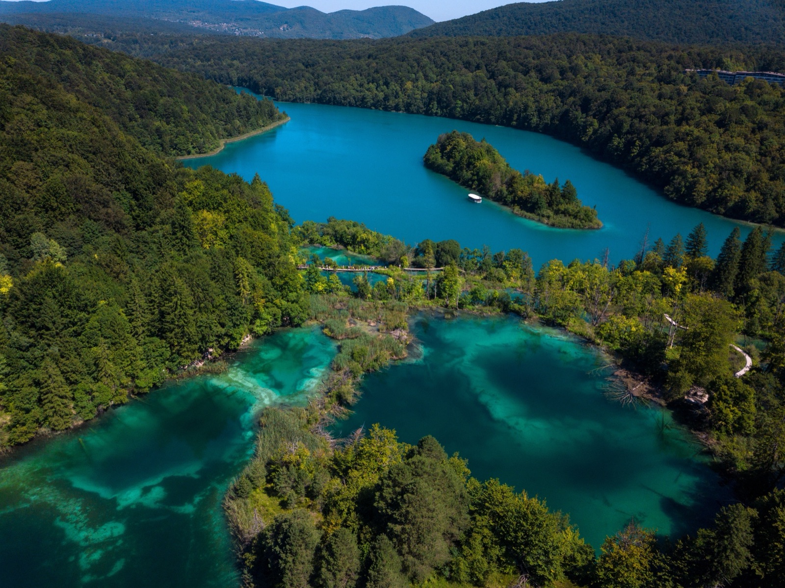
Plitvice Lakes Hiking: Medveđak, the Forest Trails and the Long K Walks
Plitvice Lakes is not only a boardwalk park. The ticket covers 22 km of trails through the lake system and another 36 km of hiking trails, and the park marks four hiking trails of its own: two short ones up the Medveđak ridge above the lakes, and two long forest trails, Plitvica (9 km) and Čorkova uvala (21 km), that start at the Labudovac panoramic train stop. If you want a hike that still keeps the lakes in view all day, the park’s longest lake programmes, K1 and K2, take 6 to 8 hours and cover 16,500 m and 17,500 m. This guide explains each option, how long it takes, how to reach the start, and the park’s own rules for walking in bear country.
The short answer
- Best half-day hike with views: Medveđak trail no. 1 from Entrance 2, about 2 hours 30 minutes, to peaks between 801 m and 889 m.
- Best quiet forest walk ending at the big falls: the Plitvica trail, 9 km from Labudovac (St3) down the Plitvica stream to the Great Waterfall and dock P3.
- Longest marked hike: the Čorkova uvala trail, 21 km, through the forests of the park’s north-west.
- Best all-day walk around the lakes themselves: programme K1 from Entrance 1 or K2 from Entrance 2, 6 to 8 hours.
- Not allowed: walking off the marked paths, cycling inside the park, and setting off on a hiking trail in bad weather.
The hiking options side by side
| Walk | Start | Length | Time | What you see |
|---|---|---|---|---|
| Medveđak trail no. 1 | Hladovina car park, Entrance 2 | Peaks loop to Entrance 1 | About 2 h 30 min | Three peaks, views of six lakes |
| Medveđak trail no. 2 | Junction (point 2) on trail no. 1 | Short link to Turčić | About 1 h 30 min | Karst ground, Turčić viewpoint |
| Plitvica trail | Labudovac (St3) | 9 km | Most of a morning | Plitvica stream, the Great Waterfall, dock P3 |
| Čorkova uvala trail | Labudovac (St3) | 21 km | A full day | Old forest, mountain meadows, Čorkova Uvala village |
| Programme K1 | Entrance 1 | 16,500 m | 6 to 8 hours | All the lakes, Tomićevo pogledalo |
| Programme K2 | Entrance 2 | 17,500 m | 6 to 8 hours | All the lakes, Tomićevo pogledalo |
The Medveđak times are the park’s own; it does not give a time for the two forest trails, so judge them by distance and your own pace. All of these are inside the ticketed park, so you need a valid day ticket, and you must still enter through the entrance and in the time slot printed on it. The tickets and routes guide explains prices and the timed entry.
Why hike at Plitvice at all
The lakes cover just under 1% of the park. Three-quarters of it is forest, spread between the Mala Kapela range to the west and north-west and Lička Plješivica to the south-east. On the boardwalks in summer you share the view with a great many people; the park had 1,492,994 visitors in 2024, and July and August are the busiest months. On the hiking trails you leave most of that behind within minutes.
The trails also show a side of Plitvice the lakeside paths cannot: beech and spruce forest left to develop naturally, karst ground full of pits and gorges, mountain meadows, and views down onto the lake system from above. The park describes its forest trails as stories about the forest systems that help the lake ecosystems thrive, with boards along the way explaining what you are looking at.
Medveđak: the ridge above the lakes
Medveđak is an 8 km wooded ridge running north-west from Plješivica, on the eastern side of the lakes, and the park calls it one of the most enchanting places in Plitvice for its many panoramic views. It has three peaks:
- Oštri Medveđak, the highest: 889 m in the park’s introduction to the ridge, and 899 m further down the same page. Either way, it looks east over Lička Plješivica, the Una valley towards Bihać, the Korana valley and the villages around Drežnik Grad and Rakovica.
- Tupi Medveđak, 868 m, with a view of six lakes: Prošćansko, Ciginovac, Okrugljak, Galovac, Gradinsko and Kozjak.
- Turčić, 801 m and the lowest, looking over Kozjak, the Great Waterfall, Hotel Jezero and the nearby villages. On a clear day the view reaches Bjelolasica, the highest mountain of the Velika Kapela massif.
The trails here are old. A path to Tupi Medveđak was built by 1894, and in 1900 a forest trail known as Blanka’s Trail was laid from the site of the old hotel to Oštri Medveđak. The ridge is also, as its name says, bear country: medvjed is Croatian for bear, and Medveđak is habitat for wolf, lynx and brown bear. Information boards along the trail explain the forest ecosystems.
Trail no. 1: the peaks loop, about 2 hours 30 minutes
Trail no. 1 starts at the Hladovina car park at Entrance 2, beside the footbridge over the main road. It begins as a gentle downhill along a forest road; 500 m down the road you reach the first junction, point 2. From there the well-kept path circles the Forestry Institute grounds and climbs to an overgrown meadow called Hrnjakuša, then on to point 3 at the foot of Oštri Medveđak.
At point 3 you choose. The climb to Oštri Medveđak continues over gentle zigzags. To carry on over Tupi Medveđak, return from the top to point 3, then follow the ridge on towards Entrance 1 (point 5). The park puts the whole of trail no. 1 at about 2 hours 30 minutes.
Because it ends at the other entrance, it works well as a one-way walk if you parked at Entrance 2 and have the time to come back along the lakes or by panoramic vehicle. Remember that your ticket is valid only at the entrance you chose when buying, so plan the day from that entrance.
Trail no. 2: the Turčić link, about 1 hour 30 minutes
Trail no. 2 runs from point 2 to point 4, a junction below Turčić, and takes about 1 hour 30 minutes. It starts as a mild climb over karst ground where, in the park’s words, there are pits, gorges and karrens at every step. It passes a stand of spruce growing on what was once grassland, then gets steeper until it meets trail no. 1 and the track to Turčić at point 4. From point 4 the last climb to Turčić takes 5 minutes and is easy.
Hikers can combine the two trails, so a sensible half-day from Entrance 2 is out on trail no. 2 to Turčić, along the ridge, and back on trail no. 1. Turčić gives the best view of Kozjak and the Great Waterfall area for the least effort.
When Medveđak is at its best
The park says the peaks are interesting in any season, but singles out early spring and late autumn, when the trees are bare and the views open up. It also says the ridge is worth seeing in winter with moderate snow. That fits the rest of the park: in winter the Lower Lakes are usually open and the Upper Lakes closed, so Medveđak is one of the few ways to see the upper part of the system from above when you cannot walk it.
The Plitvica trail: 9 km to the Great Waterfall
The Plitvica trail is the easier of the two forest trails. It starts at Labudovac (St3), the panoramic train stop at the top of the Upper Lakes, forks away from the Čorkova uvala trail and then follows the Plitvica stream downstream to the Great Waterfall and on to the boat dock P3 at Kozjačka Draga. It is 9 km long.
This is worth doing for the story alone. The Great Waterfall is not fed by the lakes at all: it is formed by the Plitvica stream, whose source is 3 km away and which belongs to none of the sixteen lakes. Walking the Plitvica trail means following that water through the forest to the point where it drops into the canyon of the Lower Lakes. The park gives the Great Waterfall’s first drop as 62 m and its total height, down to the start of the Korana, as 87 m; other sources, including another park article, give 78 m.
The park recommends arriving at Labudovac by panoramic train. On its summer timetable the vehicle from St2 to St3 runs every 30 minutes from 07:30 to 18:00, and back from St3 to St2 from 08:00 to 18:30. On the October timetable the outward vehicles ran from 07:30 to 17:00, so check the current times on the day.
The Čorkova uvala trail: 21 km through old forest
The Čorkova uvala trail is the park’s longest marked hike, at 21 km. It also starts at Labudovac, follows the Plitvica trail to the first junction, then turns off to Čorkova Uvala village, and comes back over Preka Kosa to rejoin the Plitvica trail down to dock P3.
Its point is the forest. The Čorkova uvala virgin forest lies in the north-west of the park at 860 to 1028 m and covers 84 ha. The forests and meadows along these trails are home to bear, wolf, roe deer, red deer, lynx and wildcat, and the park notes that even if you see none of them, their tracks are interesting in their own right. Expect long stretches with no one else around.
Two practical points:
- Starting or finishing at Čorkova Uvala village is only for organised groups. The village can be reached only by transport organised by the park, and groups must be accompanied by a ranger; you book this through the park’s sales office.
- Individual hikers start at St3 or P3. The park recommends visiting both Labudovac (St3) and the P3 dock at Kozjačka Draga whichever trail you choose, which the Plitvica and Čorkova uvala trails both do.
The park says both forest trails are quite long, over varied terrain, through large forests and mountain meadows with viewpoints. Treat the 21 km route as a serious day out, not a stroll.
K1 and K2: hiking the whole lake system
If what you want is distance but with the lakes beside you, the park’s K programmes are the answer. They are the longest of the eight routes around the lake system:
- K1 starts at Entrance 1 and takes 6 to 8 hours over 16,500 m.
- K2 starts at Entrance 2 and takes 6 to 8 hours over 17,500 m.
Both are walking tours of a large part of the lake zone. They walk the west shore of Kozjak and return along its east shore, reached by a short electric-boat ride. They pass the Prštavci waterfalls, the biggest and most beautiful of the Upper Lakes, and climb to the Tomićevo pogledalo viewpoint, opened in 2024 at 684.82 m, which looks over five Upper Lakes: Prošćansko, Ciginovac, Okrugljak, Veliko and Malo jezero.
For comparison, programmes C and H, which also cover both halves of the system, take 4 to 5 hours over 8,000 m from Entrance 1 and 4 to 6 hours over 8,900 m from Entrance 2, using boat and panoramic vehicle rides. The park says C and H need more fitness than the short Lower Lakes routes. K1 and K2 roughly double that distance on foot.
Start early. In October the entrances were open from 07:00 to 18:00, and a 6- to 8-hour walk leaves little slack if you arrive mid-morning. The best time to visit guide covers seasonal hours and crowds.
Choosing the right hike
- You have one day and have never been: walk K1 or K2. You see every part of the lakes and get the Tomićevo pogledalo view.
- You are staying two days: do a shorter lake programme on day one and Medveđak or the Plitvica trail on day two. The tourist board suggests two days for the lakes alone, and the park suggests three to see their different faces.
- You want a view, not a marathon: trail no. 2 to Turčić and back is the shortest worthwhile climb.
- You want to be alone in the forest: the Čorkova uvala trail.
- You are visiting in winter: Medveđak, with care and only in moderate snow.
If you are staying at Hotel Jezero, or at the Korana or Borje campsites, you pay for the first day only and enter free on the following days once the ticket is extended at reception, which makes a separate hiking day much cheaper. The accommodation article covers where to stay.
The park’s rules for the hiking trails
The park publishes a short code of conduct for its trails, and it is worth reading before you set off:
- Prepare well in advance. Find out about the trail before you go and always carry a trail map. The park’s tourism map is sold at its information offices.
- Go with a ranger if you are unsure. If you feel insecure about a trail, the park says not to set off without a national park ranger.
- Keep to the marked routes and follow the waymarks. Walking off the marked footpaths is not allowed anywhere in the park.
- Check the forecast. Do not start if it is bad: snow, heavy rain, thunderstorms or strong wind.
- Wear mountain hiking clothes and shoes.
- Respect the animals. Do not hunt, feed or disturb them, but speak loudly enough that they can hear you and keep away.
- Never hike alone.
- Take your litter with you. There are not many bins on the lakeside trails, because animals searching for food at night could get at scraps.
Two general park rules matter for hikers too: cycling is forbidden inside the park, and dogs must be on a lead. Swimming is banned in every lake and stream, including the Plitvica. Drones are not allowed.
Bears, wolves and lynx
Brown bears, grey wolves and lynx live in the park’s forests, and Medveđak is named after the bear. Most hikers never see one; these animals avoid people. The park’s advice is the standard one for bear country: never walk alone, talk as you go so that animals hear you coming, never feed or approach wildlife, and keep your food packed away. The same rule against leaving scraps explains why bins are scarce on the trails.
Weather, ice and closures
Weather in the park changes quickly, and the park may close individual trails or stop the vehicles at short notice. Under the park’s rules, rangers can close or restrict an area for up to 24 hours in exceptional conditions such as a flood, deep snow, a blizzard or a collapsed path, and the director for up to 15 days. Before you go, look at the park’s current-conditions page, which shows which areas are open and whether the boats and panoramic vehicles are running. The park also recommends phoning it on +385 53 751 015 to check conditions before arrival.
The park’s mean climate figures, from the national met service’s Gospić station, show snow on about 30 days a year and frost on many nights from November to March. The weather article has the month-by-month numbers. If you want a winter walk on snow rather than a hike, the Mukinje ski slope, about 2.5 km from Entrance 2, has sledging when there is enough natural snow.
What to carry
- Footwear with grip. Boardwalks can be wet, and the forest trails are rough and rocky in places.
- Water and food. There are few places to buy anything on the hiking trails; the park’s bistros and restaurants are near the entrances and stations.
- A waterproof and a warm layer. The park lies between 503 m and 636 m at the lakes and higher on the ridges, and it is cooler than the coast.
- The park map, paper or downloaded before you go.
- Your ticket, on your phone or printed. The boat and panoramic vehicles inside your chosen programme are included in it, so you need nothing extra to ride back to your entrance.
Hiking with a guide
The park’s own guides are only for organised groups of at least 15. For individuals, the simplest guided option is a walk with a local guide at the park. The guided walk on the tours page lasts about 4 hours, with your ticket reserved, a train or shuttle transfer and a short boat ride, and there is an early-morning version that goes in at opening time. Neither is a mountain hike, but both suit anyone who wants the lakes explained before heading up Medveđak on their own the next day. The tours compared guide sets out what each one includes.
Frequently asked questions
Are there hiking trails at Plitvice Lakes?
Yes. Besides the eight lake programmes, the park has four hiking trails: two on the Medveđak ridge and the Plitvica (9 km) and Čorkova uvala (21 km) forest trails. The ticket covers 36 km of hiking trails.
What is the longest hike at Plitvice?
The Čorkova uvala trail, at 21 km. Of the lake programmes, K2 is the longest at 17,500 m and 6 to 8 hours.
Do I need a ticket for the hiking trails?
Yes. The hiking trails are inside the national park and are covered by the normal day ticket, which you validate at your chosen entrance within your time slot.
Can I hike Plitvice in winter?
The park says Medveđak is worth seeing in winter with moderate snow, but do not start in snow, heavy rain or strong wind. In winter the Upper Lakes are usually closed until early April.
Is it safe to hike at Plitvice with bears around?
The park’s advice is never to hike alone, to talk as you walk so animals hear you, and never to feed or disturb wildlife. Stay on the marked trails and check the forecast before you set off.